
Schouwen-Duiveland topographic map
Interactive map
Click on the map to display elevation.
About this map
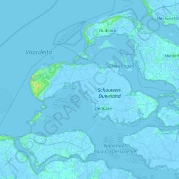
Name: Schouwen-Duiveland topographic map, elevation, terrain.
Location: Schouwen-Duiveland, Zeeland, Nederland (51.59367 3.61134 51.78152 4.20270)
Average elevation: 0 ft
Minimum elevation: -20 ft
Maximum elevation: 102 ft
Other topographic maps
Click on a map to view its topography, its elevation and its terrain.
Burgh-Haamstede
Nederland > Zeeland > Schouwen-Duiveland
Burgh-Haamstede, Schouwen-Duiveland, Zeeland, Nederland
Average elevation: 3 ft