
Grünhorn topographic map
Interactive map
Click on the map to display elevation.
About this map
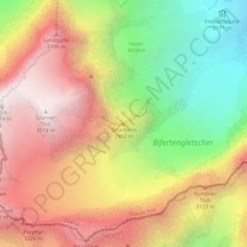
Name: Grünhorn topographic map, elevation, terrain.
Location: Grünhorn, Glarus Süd, Glaris, Suisse (46.80920 8.93428 46.80930 8.93438)
Average elevation: 9,272 ft
Minimum elevation: 6,568 ft
Maximum elevation: 11,732 ft
Other topographic maps
Click on a map to view its topography, its elevation and its terrain.
Berglistüber
Suisse > Glaris > Glarus Süd
Berglistüber, Glarus Süd, Glaris, 8783, Suisse
Average elevation: 3,862 ft
Linthal
Suisse > Glaris > Glarus Süd
Linthal, Glarus Süd, Glaris, 8783, Suisse
Average elevation: 3,596 ft