
Roscommon Municipal District topographic map
Interactive map
Click on the map to display elevation.
About this map
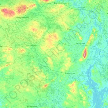
Name: Roscommon Municipal District topographic map, elevation, terrain.
Average elevation: 246 ft
Minimum elevation: 108 ft
Maximum elevation: 846 ft
Other topographic maps
Click on a map to view its topography, its elevation and its terrain.
Curraghboy
Curraghboy, Rockhill Electoral Division, Athlone Municipal District, County Roscommon, Connacht, N37 EK20, Ireland
Average elevation: 226 ft
Liberty
Liberty, Ballydangan Electoral Division, Athlone Municipal District, County Roscommon, Connacht, Ireland
Average elevation: 167 ft
Frenchpark
Ireland > County Roscommon > Frenchpark
Frenchpark, Boyle Municipal District, County Roscommon, Connacht, Ireland
Average elevation: 266 ft
Lurgan
Lurgan, Kilcolagh ED, Boyle Municipal District, County Roscommon, Connacht, Ireland
Average elevation: 230 ft