
Obersdorf topographic map
Interactive map
Click on the map to display elevation.
About this map
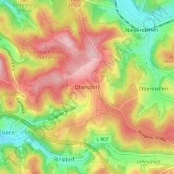
Name: Obersdorf topographic map, elevation, terrain.
Average elevation: 1,204 ft
Minimum elevation: 892 ft
Maximum elevation: 1,499 ft
Other topographic maps
Click on a map to view its topography, its elevation and its terrain.
Wilnsdorf
Allemagne > Rhénanie-du-Nord-Westphalie > Kreis Siegen-Wittgenstein > Wilnsdorf > Wilnsdorf
Wilnsdorf, Kreis Siegen-Wittgenstein, Rhénanie-du-Nord-Westphalie, 57234, Allemagne
Average elevation: 1,339 ft
Siegen
Allemagne > Rhénanie-du-Nord-Westphalie > Kreis Siegen-Wittgenstein > Siegen
Siegen, Kreis Siegen-Wittgenstein, Rhénanie-du-Nord-Westphalie, Allemagne
Average elevation: 1,135 ft