
Midões topographic map
Interactive map
Click on the map to display elevation.
About this map
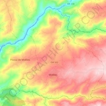
Name: Midões topographic map, elevation, terrain.
Location: Midões, Tábua, Coimbra, 3420-149, Portugal (40.37046 -7.99315 40.42396 -7.91254)
Average elevation: 896 ft
Minimum elevation: 394 ft
Maximum elevation: 1,283 ft
Other topographic maps
Click on a map to view its topography, its elevation and its terrain.
São Fagundo
São Fagundo, Tábua, Coimbra, 3420-313, Portugal
Average elevation: 709 ft
Pousadouros
Portugal > Coimbra > Tábua > Mouronho
Pousadouros, Mouronho, Tábua, Coimbra, 3300-416, Portugal
Average elevation: 751 ft
Vila do Mato
Portugal > Coimbra > Tábua > Midões
Vila do Mato, Midões, Tábua, Coimbra, 3420-149, Portugal
Average elevation: 883 ft
Covas e Vila Nova de Oliveirinha
Covas e Vila Nova de Oliveirinha, Tábua, Coimbra, Portugal
Average elevation: 1,237 ft
Carragosela
Carragosela, Espariz e Sinde, Tábua, Coimbra, 3420-330, Portugal
Average elevation: 978 ft
Póvoa de Midões
Póvoa de Midões, Tábua, Coimbra, Portugal
Average elevation: 804 ft