
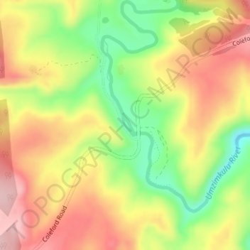
Umzimkulu River topographic map
Interactive map
Click on the map to display elevation.
About this map
Name: Umzimkulu River topographic map, elevation, terrain.
Average elevation: 4,718 ft
Minimum elevation: 4,373 ft
Maximum elevation: 5,013 ft
Other topographic maps
Click on a map to view its topography, its elevation and its terrain.
Umzimkulu
South Africa > KwaZulu-Natal > Sisonke District Municipality > Kwa Sani Local Municipality
Umzimkulu, Kwa Sani Ward 3, Kwa Sani Local Municipality, Sisonke District Municipality, KwaZulu-Natal, South Africa
Average elevation: 4,892 ft
Lake Naverone
South Africa > KwaZulu-Natal > Sisonke District Municipality > Kwa Sani Local Municipality
Lake Naverone, Kwa Sani Ward 4, Kwa Sani Local Municipality, Sisonke District Municipality, KwaZulu-Natal, South Africa
Average elevation: 5,617 ft
Underberg
South Africa > KwaZulu-Natal > Sisonke District Municipality > Kwa Sani Local Municipality
Underberg, Kwa Sani Local Municipality, Sisonke District Municipality, KwaZulu-Natal, South Africa
Average elevation: 5,092 ft
Himeville
South Africa > KwaZulu-Natal > Sisonke District Municipality > Kwa Sani Local Municipality
Himeville, Kwa Sani Local Municipality, Sisonke District Municipality, KwaZulu-Natal, South Africa
Average elevation: 5,036 ft
Garden Castle
South Africa > KwaZulu-Natal > Sisonke District Municipality > Kwa Sani Local Municipality
Garden Castle, Kwa Sani Local Municipality, Sisonke District Municipality, KwaZulu-Natal, South Africa
Average elevation: 6,145 ft