
Ratingen topographic map
Click on the map to display elevation.
About this map
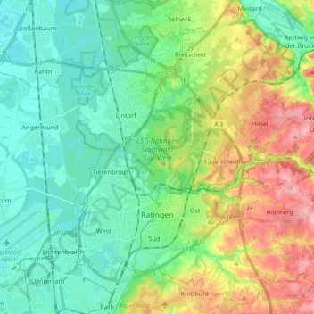
Name: Ratingen topographic map, elevation, terrain.
Location: Ratingen, Kreis Mettmann, North Rhine-Westphalia, Germany (51.26453 6.80124 51.37179 6.98309)
Average elevation: 233 ft
Minimum elevation: 89 ft
Maximum elevation: 551 ft
Other topographic maps
Click on a map to view its topography, its elevation and its terrain.
Neander Valley;Neandertal Valley
Germany > North Rhine-Westphalia > Kreis Mettmann > Mettmann
Average elevation: 387 ft
Abtsküche / Haus Hetterscheidt
Germany > North Rhine-Westphalia > Kreis Mettmann > Heiligenhaus > Tüschen
Average elevation: 551 ft