Geolocate

Cairo topographic map

Click on the map to display elevation.

👉 Easily get elevation data in JSON, GeoTIFF and KML formats using Elevation API
Thank you for supporting this site ❤️
Make a donation

About this map

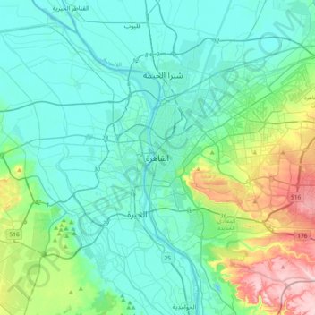
Name: Cairo topographic map, elevation, terrain.

Location: Cairo, 11519, Egypt (29.88439 31.07573 30.20439 31.39573)

Average elevation: 217 ft

Minimum elevation: 16 ft

Maximum elevation: 1,083 ft

Other topographic maps

Click on a map to view its topography, its elevation and its terrain.

Almaza Park

Egypt > Cairo > Cairo

Average elevation: 246 ft

Fostat garden

Egypt > Cairo > Cairo > EL Sheikh Mubarak

Average elevation: 108 ft

Fustat

Egypt > Cairo > Cairo > EL Sheikh Mubarak

Average elevation: 95 ft

Gear up for your next adventure:

🧷Carabiner Set - Durable clips for gear attachment
📻Weather Alert Radios - Stay informed of storm risks while off-the-grid
📦Gear Storage Bags - Organize and protect outdoor equipment
🛡️Bear Spray Outdoor - Protection in bear country hikes
📱Solar Portable Charger - Solar power bank for charging devices off‑grid

As an Amazon Associate, this site earns from qualifying purchases at no extra cost to you.