
El Carmen de Pijili topographic map
Interactive map
Click on the map to display elevation.
About this map
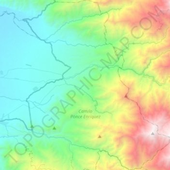
Name: El Carmen de Pijili topographic map, elevation, terrain.
Location: El Carmen de Pijili, Santa Isabel, Azuay, Ecuador (-3.05073 -79.65946 -2.78917 -79.43103)
Average elevation: 3,350 ft
Minimum elevation: 59 ft
Maximum elevation: 12,159 ft
Other topographic maps
Click on a map to view its topography, its elevation and its terrain.
Atalaya
Ecuador > Azuay > Santa Isabel
Atalaya, Abdon Calderon (La Union), Santa Isabel, Azuay, Ecuador
Average elevation: 4,239 ft
Abdon Calderon (La Union)
Ecuador > Azuay > Santa Isabel
Abdon Calderon (La Union), Santa Isabel, Azuay, Ecuador
Average elevation: 5,587 ft
Jubones
Ecuador > Azuay > Santa Isabel > Jubones
Jubones, Santa Isabel (Chaguarurco), Santa Isabel, Azuay, Ecuador
Average elevation: 3,488 ft