
Itbayat Island topographic map
Interactive map
Click on the map to display elevation.
About this map
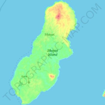
Name: Itbayat Island topographic map, elevation, terrain.
Average elevation: 102 ft
Minimum elevation: 0 ft
Maximum elevation: 1,089 ft
Other topographic maps
Click on a map to view its topography, its elevation and its terrain.
Y'ami Island
Philippines > Batanes > Itbayat
Y'ami Island, Itbayat, Batanes, Cagayan Valley, 3905, Philippines
Average elevation: 30 ft