Geolocate

Trindade topographic map

Click on the map to display elevation.

About this map

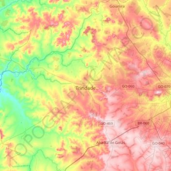
Name: Trindade topographic map, elevation, terrain.

Location: Trindade, Região Geográfica Imediata de Goiânia, Região Geográfica Intermediária de Goiânia, Goiás, Central-West Region, Brazil (-16.81287 -49.69579 -16.48942 -49.37900)

Average elevation: 2,474 ft

Minimum elevation: 1,936 ft

Maximum elevation: 2,986 ft

Other topographic maps

Click on a map to view its topography, its elevation and its terrain.

Bernarda

Brazil > Goiás > São Francisco de Goiás

Average elevation: 2,415 ft

Gercinápolis

Brazil > Goiás > Varjão

Average elevation: 1,946 ft

Poço Tranquílitas

Brazil > Goiás > Alto Paraíso de Goiás

Average elevation: 4,393 ft

Cachoeira Santa Bárbara

Brazil > Goiás > Cavalcante

Average elevation: 3,799 ft

Gameleira

Brazil > Goiás > Uruaçu

Average elevation: 2,215 ft

Niquelândia

Brazil > Goiás > Niquelândia > Niquelândia

Average elevation: 2,320 ft

Gear up for your next adventure:

🔥Plasma Lighters - Windproof lighters that work in any weather condition
☀️Outdoor Sunscreen - High protection sunscreen for outdoor activities
🪶Compact Camp Shovel - Folding shovel for campsite tasks
🔥Fast-Boil Camping Stoves - Efficient cooking systems for quick trail meals
🚁Photography Drones - Capture stunning aerial views of landforms and topography

As an Amazon Associate, this site earns from qualifying purchases at no extra cost to you.