Geolocate

Oas topographic map

Click on the map to display elevation.

About this map

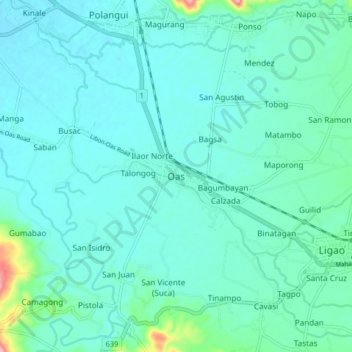
Name: Oas topographic map, elevation, terrain.

Location: Oas, Albay, Bicol Region, 4505, Philippines (13.21704 123.46017 13.29704 123.54017)

Average elevation: 128 ft

Minimum elevation: 56 ft

Maximum elevation: 568 ft

Other topographic maps

Click on a map to view its topography, its elevation and its terrain.

Peñaranda Park

Philippines > Albay > Legazpi > Baño

Average elevation: 121 ft

Rapu-Rapu

Philippines > Albay

Average elevation: 59 ft

Malilipot

Philippines > Albay

Average elevation: 860 ft

Gear up for your next adventure:

Solar GPS Watches - Advanced multisport watches with built-in topographic maps
💧Water Filtration Bottles - Safely drink from streams and lakes while exploring
🧭Outdoor Navigation Book - Learn advanced navigation skills
🥾Women's Hiking Boots - Top-rated trail boots with ankle support and superior grip
🏫Relief Map Kits - Hands-on tools for teaching landforms and elevation

As an Amazon Associate, this site earns from qualifying purchases at no extra cost to you.