
Le Pré de la Mer topographic map
Interactive map
Click on the map to display elevation.
About this map
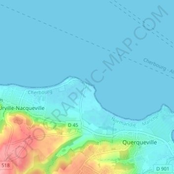
Name: Le Pré de la Mer topographic map, elevation, terrain.
Average elevation: 52 ft
Minimum elevation: 0 ft
Maximum elevation: 364 ft
Other topographic maps
Click on a map to view its topography, its elevation and its terrain.
La Rivière
France > Normandie > Manche > La Hague > Urville-Nacqueville
La Rivière, Urville-Nacqueville, La Hague, Cherbourg, Manche, Normandie, France métropolitaine, 50460, France
Average elevation: 108 ft
Hameau Capelle
France > Normandie > Manche > La Hague > Urville-Nacqueville
Hameau Capelle, Urville-Nacqueville, La Hague, Cherbourg, Manche, Normandie, France métropolitaine, 50460, France
Average elevation: 157 ft