
Bielstein topographic map
Interactive map
Click on the map to display elevation.
About this map
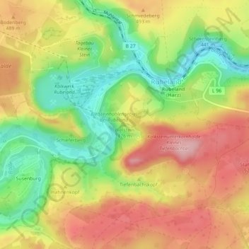
Name: Bielstein topographic map, elevation, terrain.
Average elevation: 1,509 ft
Minimum elevation: 1,243 ft
Maximum elevation: 1,755 ft
Other topographic maps
Click on a map to view its topography, its elevation and its terrain.
Königshütte
Deutschland > Sachsen-Anhalt > Oberharz am Brocken
Königshütte, Oberharz am Brocken, Landkreis Harz, Sachsen-Anhalt, Deutschland
Average elevation: 1,588 ft
Klingenberg
Deutschland > Sachsen-Anhalt > Oberharz am Brocken
Klingenberg, Oberharz am Brocken, Landkreis Harz, Sachsen-Anhalt, 38875, Deutschland
Average elevation: 1,572 ft
Rotestein
Deutschland > Sachsen-Anhalt > Oberharz am Brocken
Rotestein, Oberharz am Brocken, Landkreis Harz, Sachsen-Anhalt, 38889, Deutschland
Average elevation: 1,473 ft