
Make a donation
Gear up for your next adventure:
As an Amazon Associate, this site earns from qualifying purchases at no extra cost to you.
Santo Antônio do Pinhal topographic map
Click on the map to display elevation.
Make a donation
Gear up for your next adventure:
As an Amazon Associate, this site earns from qualifying purchases at no extra cost to you.
Santo Antônio do Pinhal
Santo Antônio do Pinhal is a municipality in the state of São Paulo in Brazil. It is part of the Metropolitan Region of Vale do Paraíba e Litoral Norte. The population is 6,827 (2020 est.) in an area of 133.01 km². The elevation is 1,080 m (3543 ft). It is situated near Campos do Jordão, some 150 km away from São Paulo.
Make a donation
Gear up for your next adventure:
As an Amazon Associate, this site earns from qualifying purchases at no extra cost to you.
About this map
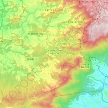
Name: Santo Antônio do Pinhal topographic map, elevation, terrain.
Average elevation: 3,694 ft
Minimum elevation: 1,873 ft
Maximum elevation: 6,135 ft
Make a donation
Gear up for your next adventure:
As an Amazon Associate, this site earns from qualifying purchases at no extra cost to you.
Other topographic maps
Click on a map to view its topography, its elevation and its terrain.
São Francisco Xavier
Brazil > São Paulo > Região Metropolitana do Vale do Paraíba e Litoral Norte > São José dos Campos
Average elevation: 2,795 ft
São José dos Campos
Brazil > São Paulo > Região Metropolitana do Vale do Paraíba e Litoral Norte > São José dos Campos
In the urban area, there are rolling plateaus and hills. The lowest elevation in the city (and also in the municipality) is found in the Paraíba do Sul River, at a mean elevation of 550 m.
Average elevation: 2,080 ft