
Make a donation
Gear up for your next adventure:
As an Amazon Associate, this site earns from qualifying purchases at no extra cost to you.
Riom-ès-Montagnes topographic map
Click on the map to display elevation.
Make a donation
Gear up for your next adventure:
As an Amazon Associate, this site earns from qualifying purchases at no extra cost to you.
Riom-ès-Montagnes
Main town of the "Pays Gentiane", the city is located northwest of the department of Cantal, in the heart of the regional natural park of Auvergne Volcanoes. Riom-ès-Montagnes is located between the Monts Dore and the Mounts of Cantal at an altitude of 840 meters.
Make a donation
Gear up for your next adventure:
As an Amazon Associate, this site earns from qualifying purchases at no extra cost to you.
About this map
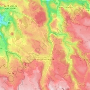
Name: Riom-ès-Montagnes topographic map, elevation, terrain.
Average elevation: 2,920 ft
Minimum elevation: 1,801 ft
Maximum elevation: 3,704 ft
Make a donation
Gear up for your next adventure:
As an Amazon Associate, this site earns from qualifying purchases at no extra cost to you.
Other topographic maps
Click on a map to view its topography, its elevation and its terrain.
Make a donation
Gear up for your next adventure:
As an Amazon Associate, this site earns from qualifying purchases at no extra cost to you.
Les Trois Pierres
France > Auvergne-Rhône-Alpes > Cantal > Albepierre-Bredons
Average elevation: 4,019 ft
Make a donation
Gear up for your next adventure:
As an Amazon Associate, this site earns from qualifying purchases at no extra cost to you.
La Roche
France > Auvergne-Rhône-Alpes > Cantal > Val d'Arcomie > Saint-Marc
Average elevation: 3,130 ft