
Katerini topographic map
Interactive map
Click on the map to display elevation.
About this map
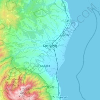
Name: Katerini topographic map, elevation, terrain.
Average elevation: 1,093 ft
Minimum elevation: -13 ft
Maximum elevation: 9,478 ft
Other topographic maps
Click on a map to view its topography, its elevation and its terrain.
Katerini
Griechenland > Makedonien - Thrakien > Katerini
Katerini, Δήμος Κατερίνης, Regionalbezirk Pieria, Makedonien - Thrakien, 601 00, Griechenland
Average elevation: 610 ft