Geolocate

Hoeselt topographic map

Click on the map to display elevation.

About this map

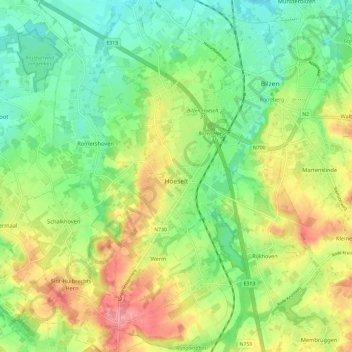
Name: Hoeselt topographic map, elevation, terrain.

Location: Hoeselt, Tongeren, Limburg, Flanders, Belgium (50.81374 5.42912 50.88843 5.51333)

Average elevation: 240 ft

Minimum elevation: 121 ft

Maximum elevation: 410 ft

Other topographic maps

Click on a map to view its topography, its elevation and its terrain.

Veurs

Belgium > Limburg > Tongeren > Sint-Martens-Voeren

Average elevation: 699 ft

Rullekoven

Belgium > Limburg > Tongeren > Borgloon > Kerniel > Rullekoven

Average elevation: 276 ft

Gear up for your next adventure:

🧼Biodegradable Camping Soap - Eco‑friendly soap for outdoor hygiene
🚪Portable Camp Chair - Foldable chair for comfort at camp
🛠️Backpacking Tool Kit - Essential toolkit for outdoor repairs
🥩Freeze-Dried Meals - Nutritious and lightweight food for remote expeditions
🖼️Topo Map Wall Art - Decorative topographic prints of famous peaks and regions

As an Amazon Associate, this site earns from qualifying purchases at no extra cost to you.