
Casteljau topographic map
Interactive map
Click on the map to display elevation.
About this map
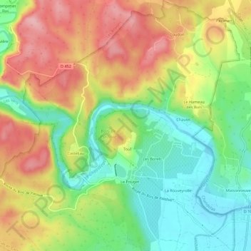
Name: Casteljau topographic map, elevation, terrain.
Average elevation: 591 ft
Minimum elevation: 354 ft
Maximum elevation: 860 ft
Other topographic maps
Click on a map to view its topography, its elevation and its terrain.
Mazet
France > Auvergne-Rhône-Alpes > Ardèche > Berrias-et-Casteljau
Mazet, Casteljau, Berrias-et-Casteljau, Largentière, Ardèche, Auvergne-Rhône-Alpes, France métropolitaine, 07460, France
Average elevation: 561 ft
Le Hameau des Buis
France > Auvergne-Rhône-Alpes > Ardèche > Berrias-et-Casteljau
Le Hameau des Buis, Casteljau, Berrias-et-Casteljau, Largentière, Ardèche, Auvergne-Rhône-Alpes, France métropolitaine, 07460, France
Average elevation: 558 ft
Grotte de la Tardive
France > Auvergne-Rhône-Alpes > Ardèche > Berrias-et-Casteljau > Casteljau
Grotte de la Tardive, La Presqu'Île, Casteljau, Berrias-et-Casteljau, Largentière, Ardèche, Auvergne-Rhône-Alpes, France métropolitaine, 07460, France
Average elevation: 584 ft
Le Pouget
France > Auvergne-Rhône-Alpes > Ardèche > Berrias-et-Casteljau
Le Pouget, Casteljau, Berrias-et-Casteljau, Largentière, Ardèche, Auvergne-Rhône-Alpes, France métropolitaine, 07460, France
Average elevation: 531 ft
Les Borels
France > Auvergne-Rhône-Alpes > Ardèche > Berrias-et-Casteljau
Les Borels, Casteljau, Berrias-et-Casteljau, Largentière, Ardèche, Auvergne-Rhône-Alpes, France métropolitaine, 07460, France
Average elevation: 538 ft
Berrias
France > Auvergne-Rhône-Alpes > Ardèche > Berrias-et-Casteljau
Berrias, Berrias-et-Casteljau, Largentière, Ardèche, Auvergne-Rhône-Alpes, France métropolitaine, 07460, France
Average elevation: 571 ft