
Oued Seguen topographic map
Interactive map
Click on the map to display elevation.
About this map
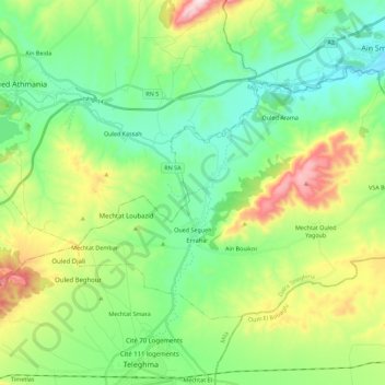
Name: Oued Seguen topographic map, elevation, terrain.
Location: Oued Seguen, Daïra Teleghma, Mila, 43031, Algérie (36.13921 6.32193 36.25769 6.54563)
Average elevation: 2,552 ft
Minimum elevation: 1,991 ft
Maximum elevation: 3,852 ft
Other topographic maps
Click on a map to view its topography, its elevation and its terrain.
VSA Ben Boulaid
Algérie > Mila > Daïra Teleghma
VSA Ben Boulaid, Oued Seguen, Daïra Teleghma, Mila, Algérie
Average elevation: 2,602 ft
Teleghma
Algérie > Mila > Daïra Teleghma
Teleghma, Daïra Teleghma, Mila, Algérie
Average elevation: 2,812 ft
Mechtat Ouled Yagoub
Algérie > Mila > Daïra Teleghma > Mechtat Ouled Yagoub
Mechtat Ouled Yagoub, Oued Seguen, Daïra Teleghma, Mila, Algérie
Average elevation: 2,805 ft