
Make a donation
Gear up for your next adventure:
As an Amazon Associate, this site earns from qualifying purchases at no extra cost to you.
Covington topographic map
Click on the map to display elevation.
Make a donation
Gear up for your next adventure:
As an Amazon Associate, this site earns from qualifying purchases at no extra cost to you.
About this map
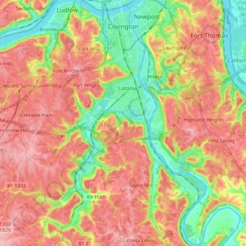
Name: Covington topographic map, elevation, terrain.
Location: Covington, Kenton County, Kentucky, United States (38.96456 -84.55480 39.09768 -84.47971)
Average elevation: 709 ft
Minimum elevation: 456 ft
Maximum elevation: 935 ft
Kenton County trails, hiking, mountain biking, running and outdoor activities
Make a donation
Gear up for your next adventure:
As an Amazon Associate, this site earns from qualifying purchases at no extra cost to you.
Other topographic maps
Click on a map to view its topography, its elevation and its terrain.
Make a donation
Gear up for your next adventure:
As an Amazon Associate, this site earns from qualifying purchases at no extra cost to you.
Sunny Acres
United States > Kentucky > Kenton County > Taylor Mill > Sunny Acres
Average elevation: 709 ft