Geolocate

Sagar topographic map

Click on the map to display elevation.

Sagar

Sagar has an average elevation of 427 metres (1401 ft) and is located in the central part of India, just north of the upper limit of the Vindhya mountain ranges.here is a lake in middle of the city.

Wikipedia (CC-BY-SA 3.0)

About this map

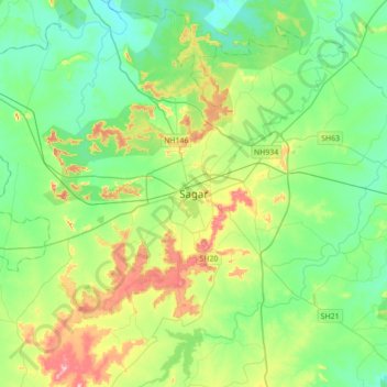
Name: Sagar topographic map, elevation, terrain.

Location: Sagar, Sagar Nagar Tahsil, Sagar, Madhya Pradesh, 470001, India (23.68178 78.58668 24.00178 78.90668)

Average elevation: 1,690 ft

Minimum elevation: 1,512 ft

Maximum elevation: 2,136 ft

Gear up for your next adventure:

🎁Geography Themed Gifts - Unique gift ideas for map lovers and geography enthusiasts
📚Navigation Handbooks - Master the art of reading topographic maps and using a compass
📻Weather Alert Radios - Stay informed of storm risks while off-the-grid
🚁Photography Drones - Capture stunning aerial views of landforms and topography
💧Water Filtration Bottles - Safely drink from streams and lakes while exploring

As an Amazon Associate, this site earns from qualifying purchases at no extra cost to you.