
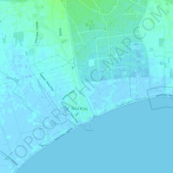
Municipal Unit of Nea Kios topographic map
Interactive map
Click on the map to display elevation.
About this map
Name: Municipal Unit of Nea Kios topographic map, elevation, terrain.
Average elevation: 7 ft
Minimum elevation: -10 ft
Maximum elevation: 30 ft
Other topographic maps
Click on a map to view its topography, its elevation and its terrain.
Nafplio
Greece > Peloponnese, Western Greece and the Ionian > Argolis Regional Unit > Municipal Unit of Nafplio
Nafplio, Municipal Unit of Nafplio, Municipality of Nafplio, Argolis Regional Unit, Peloponnese Region, Peloponnese, Western Greece and the Ionian, 211 00, Greece
Average elevation: 118 ft
Myli
Greece > Peloponnese, Western Greece and the Ionian > Argolis Regional Unit > Municipal Unit of Lerna
Myli, Municipal Unit of Lerna, Municipality of Argos and Mykines, Argolis Regional Unit, Peloponnese Region, Peloponnese, Western Greece and the Ionian, 212 00, Greece
Average elevation: 102 ft
Municipal Unit of Mykines
Greece > Peloponnese, Western Greece and the Ionian > Argolis Regional Unit
Municipal Unit of Mykines, Municipality of Argos and Mykines, Argolis Regional Unit, Peloponnese Region, Peloponnese, Western Greece and the Ionian, Greece
Average elevation: 1,024 ft
Kilada
Greece > Peloponnese, Western Greece and the Ionian > Argolis Regional Unit > Municipal Unit of Kranidi
Kilada, Municipal Unit of Kranidi, Municipality of Ermionida, Argolis Regional Unit, Peloponnese Region, Peloponnese, Western Greece and the Ionian, 213 00, Greece
Average elevation: 56 ft