Geolocate

Northlew topographic map

Click on the map to display elevation.

About this map

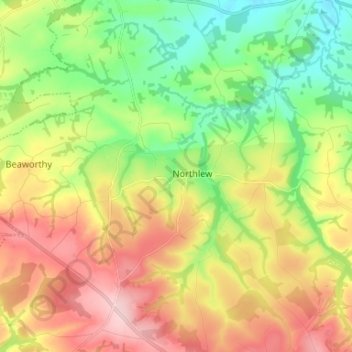
Name: Northlew topographic map, elevation, terrain.

Location: Northlew, West Devon, Devon, England, United Kingdom (50.73010 -4.19075 50.81340 -4.05892)

Average elevation: 531 ft

Minimum elevation: 223 ft

Maximum elevation: 932 ft

Gear up for your next adventure:

📡Handheld GPS Device - Reliable handheld GPS for outdoor navigation
📚USA Hiking Guide Books - Top trail guides and map books
🍳Camping Cook Set - Complete cookware for outdoor meals
🧣Merino Neck Gaiters - Multi-functional headwear for wind and sun protection
☀️Outdoor Sunscreen - High protection sunscreen for outdoor activities

As an Amazon Associate, this site earns from qualifying purchases at no extra cost to you.