
Great Chattenden Wood topographic map
Interactive map
Click on the map to display elevation.
About this map
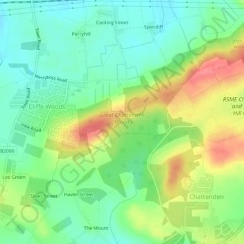
Name: Great Chattenden Wood topographic map, elevation, terrain.
Average elevation: 108 ft
Minimum elevation: 16 ft
Maximum elevation: 246 ft
Other topographic maps
Click on a map to view its topography, its elevation and its terrain.
Lee Green
United Kingdom > England > Medway > Frindsbury
Lee Green, Frindsbury Extra, Frindsbury, Medway, England, ME3 8EX, United Kingdom
Average elevation: 89 ft
Upnor Castle
United Kingdom > England > Medway > Frindsbury
Upnor Castle, High Street, Frindsbury Extra, Upper Upnor, Frindsbury, Medway, England, ME2 4XG, United Kingdom
Average elevation: 46 ft