
Make a donation
Gear up for your next adventure:
As an Amazon Associate, this site earns from qualifying purchases at no extra cost to you.
Dobel topographic map
Click on the map to display elevation.
Make a donation
Gear up for your next adventure:
As an Amazon Associate, this site earns from qualifying purchases at no extra cost to you.
Dobel
The municipality (Gemeinde) of Dobel is located situated in the district of Calw, in the German state of Baden-Württemberg. Dobel lies at the northwest corner of the district, bordering the districts of Rastatt and the Enz. The municipal area is physically located in the Grinde area of the Black Forest, on a plateau between the valleys of the Enz and Alb rivers. Elevation above sea level in the municipal area ranges from a high of 882 meters (2,894 ft) Normalnull (NN) at the top of the Rosskopf to a low of 405 meters (1,329 ft) NN.
Make a donation
Gear up for your next adventure:
As an Amazon Associate, this site earns from qualifying purchases at no extra cost to you.
About this map
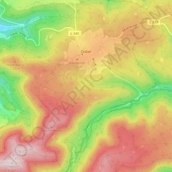
Name: Dobel topographic map, elevation, terrain.
Average elevation: 2,159 ft
Minimum elevation: 1,201 ft
Maximum elevation: 2,956 ft
Make a donation
Gear up for your next adventure:
As an Amazon Associate, this site earns from qualifying purchases at no extra cost to you.
Other topographic maps
Click on a map to view its topography, its elevation and its terrain.
Bad Teinach
Germany > Baden-Württemberg > Landkreis Calw
The township (Stadt) of Bad Teinach-Zavelstein is located at the center of the district of Calw, in Baden-Württemberg, one of the 16 States of the Federal Republic of Germany. Bad Teinach-Zavelstein's municipal area rests upon the plateau of the Enz and Nagold rivers, a landscape defined by severe river…
Average elevation: 1,827 ft
Zieflensberg
Germany > Baden-Württemberg > Landkreis Calw > Bad Herrenalb > Zieflensberg
Average elevation: 2,192 ft
Make a donation
Gear up for your next adventure:
As an Amazon Associate, this site earns from qualifying purchases at no extra cost to you.