
Make a donation
Gear up for your next adventure:
As an Amazon Associate, this site earns from qualifying purchases at no extra cost to you.
Saint-Nazaire topographic map
Click on the map to display elevation.
Make a donation
Gear up for your next adventure:
As an Amazon Associate, this site earns from qualifying purchases at no extra cost to you.
Saint-Nazaire
According to INSEE, Saint-Nazaire is the commune-center of an urban unit (commonly: agglomeration) which counted 186,760 inhabitants in 2018, gathering 17 communes of the Loire estuary. This unit is the urban center of the urban area of Saint-Nazaire (24 communes), which had 213,675 inhabitants in 2018 and extending over Brière and almost all of the Guérande peninsula. The eastern part of the town is on the alluvial terrain between the Brière and the Loire estuary. The western part, more extensive, corresponds to the extension of the hillside of Guérande: the relief is hilly and of higher altitude, where one finds a granite and metamorphic base. Geologically, Saint-Nazaire is located in the Armorican massif.
Make a donation
Gear up for your next adventure:
As an Amazon Associate, this site earns from qualifying purchases at no extra cost to you.
About this map
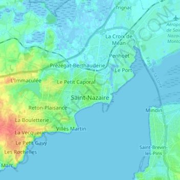
Name: Saint-Nazaire topographic map, elevation, terrain.
Average elevation: 20 ft
Minimum elevation: -16 ft
Maximum elevation: 151 ft
Make a donation
Gear up for your next adventure:
As an Amazon Associate, this site earns from qualifying purchases at no extra cost to you.
Other topographic maps
Click on a map to view its topography, its elevation and its terrain.
Plan d'eau privé
France > Pays de la Loire > Loire-Atlantique > Prinquiau > Clas
Average elevation: 177 ft