
Pine Hill topographic map
Interactive map
Click on the map to display elevation.
About this map
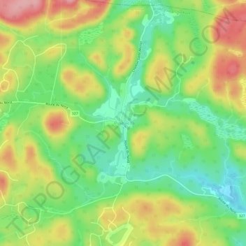
Name: Pine Hill topographic map, elevation, terrain.
Average elevation: 896 ft
Minimum elevation: 696 ft
Maximum elevation: 1,145 ft
Other topographic maps
Click on a map to view its topography, its elevation and its terrain.
Brownsburg
Canada > Québec > Argenteuil > Brownsburg-Chatham
Brownsburg, Brownsburg-Chatham, Argenteuil, Laurentides, Québec, J8G 3A4, Canada
Average elevation: 404 ft
Dalesville
Canada > Québec > Argenteuil > Brownsburg-Chatham
Dalesville, Brownsburg-Chatham, Argenteuil, Laurentides, Québec, J8G 3C4, Canada
Average elevation: 633 ft