
Bourne topographic map
Interactive map
Click on the map to display elevation.
About this map
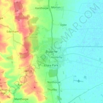
Name: Bourne topographic map, elevation, terrain.
Average elevation: 69 ft
Minimum elevation: -3 ft
Maximum elevation: 226 ft
Other topographic maps
Click on a map to view its topography, its elevation and its terrain.
Bridge Hills
United Kingdom > England > Lincolnshire > South Kesteven
Bridge Hills, Priory Farm, Horbling, South Kesteven, Lincolnshire, England, NG34 0JG, United Kingdom
Average elevation: 13 ft
Grantham
United Kingdom > England > Lincolnshire > South Kesteven
Grantham, South Kesteven, Lincolnshire, England, NG31 6LJ, United Kingdom
Average elevation: 285 ft
Thurlby
United Kingdom > England > Lincolnshire > South Kesteven > Thurlby
Thurlby, South Kesteven, Lincolnshire, East Midlands, England, PE10 0QD, United Kingdom
Average elevation: 66 ft
Stamford
United Kingdom > England > Lincolnshire > South Kesteven
Stamford, South Kesteven, Lincolnshire, England, PE9 2AJ, United Kingdom
Average elevation: 171 ft
Barkston
United Kingdom > England > Lincolnshire > South Kesteven
Barkston, South Kesteven, Lincolnshire, England, NG32 2NH, United Kingdom
Average elevation: 203 ft
Grantham
United Kingdom > England > Lincolnshire > South Kesteven
Grantham, South Kesteven, Lincolnshire, England, United Kingdom
Average elevation: 279 ft