Geolocate

Païta topographic map

Click on the map to display elevation.

About this map
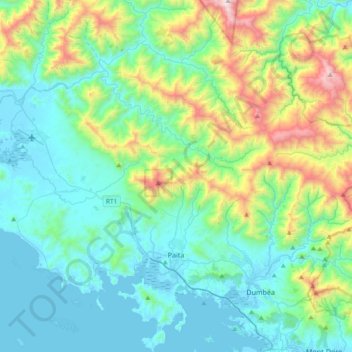
Name: Païta topographic map, elevation, terrain.

Location: Païta, South Province, New Caledonia, France (-22.22665 166.11174 -21.87992 166.47285)

Average elevation: 1,122 ft

Minimum elevation: -7 ft

Maximum elevation: 5,207 ft

Other topographic maps

Click on a map to view its topography, its elevation and its terrain.

Ouipoin

France > South Province > La Foa

Average elevation: 1,047 ft

BS4

France > South Province > Yaté

Average elevation: 659 ft

BS16

France > South Province > Yaté

Average elevation: 636 ft

St Maurice

France > South Province > Thio

Average elevation: 1,096 ft

Tô De

France > South Province > Thio

Average elevation: 1,617 ft

Gear up for your next adventure:

👟Men's Trail Runners - Lightweight footwear for fast-paced exploration and light hiking
🪶Compact Camp Shovel - Folding shovel for campsite tasks
🎒Hydration Pack - Hands‑free water reservoir for long hikes
🔦Compact Flashlight - Reliable flashlight for emergencies
😴Insulated Sleeping Pads - Compact and warm pads for high-elevation camping

As an Amazon Associate, this site earns from qualifying purchases at no extra cost to you.