
Zaorejas topographic map
Interactive map
Click on the map to display elevation.
About this map
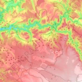
Name: Zaorejas topographic map, elevation, terrain.
Location: Zaorejas, Guadalajara, Castilla-La Mancha, 19495, España (40.67599 -2.32873 40.84615 -2.07095)
Average elevation: 3,898 ft
Minimum elevation: 2,700 ft
Maximum elevation: 4,711 ft
Other topographic maps
Click on a map to view its topography, its elevation and its terrain.
La Covacha
España > Castilla-La Mancha > Zaorejas
La Covacha, Zaorejas, Guadalajara, Castilla-La Mancha, España
Average elevation: 3,858 ft