
San Joaquín topographic map
Interactive map
Click on the map to display elevation.
About this map
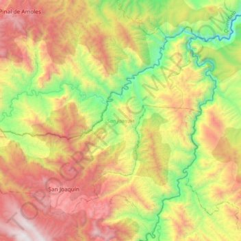
Name: San Joaquín topographic map, elevation, terrain.
Location: San Joaquín, Querétaro, Mexico (20.88191 -99.68584 21.11640 -99.36325)
Average elevation: 5,420 ft
Minimum elevation: 1,811 ft
Maximum elevation: 10,016 ft
Other topographic maps
Click on a map to view its topography, its elevation and its terrain.
La Cañada
Mexico > Querétaro > Pinal de Amoles > La Cañada
La Cañada, Pinal de Amoles, Querétaro, Mexico
Average elevation: 8,448 ft
Los Ángeles
Mexico > Querétaro > Los Ángeles
Los Ángeles, Corregidora, Querétaro, 76927, Mexico
Average elevation: 6,083 ft
San Juan del Río
Mexico > Querétaro > San Juan del Río
San Juan del Río, Querétaro, 76803, Mexico
Average elevation: 6,873 ft