
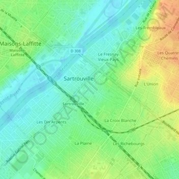
La Vaudoire topographic map
Interactive map
Click on the map to display elevation.
About this map
Name: La Vaudoire topographic map, elevation, terrain.
Average elevation: 125 ft
Minimum elevation: 72 ft
Maximum elevation: 203 ft
Other topographic maps
Click on a map to view its topography, its elevation and its terrain.
L'Union
France > Île-de-France > Sartrouville
L'Union, Sartrouville, Saint-Germain-en-Laye, Yvelines, Île-de-France, France métropolitaine, 78500, France
Average elevation: 151 ft
Les Indes
France > Île-de-France > Sartrouville
Les Indes, Sartrouville, Saint-Germain-en-Laye, Yvelines, Île-de-France, France métropolitaine, 78500, France
Average elevation: 174 ft
La Plaine
France > Île-de-France > Sartrouville
La Plaine, Sartrouville, Saint-Germain-en-Laye, Yvelines, Île-de-France, France métropolitaine, 78500, France
Average elevation: 135 ft