Geolocate

Urubamba topographic map

Click on the map to display elevation.

About this map
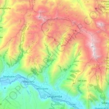
Name: Urubamba topographic map, elevation, terrain.

Location: Urubamba, Province of Urubamba, Cusco, 08661, Peru (-13.31312 -72.21894 -13.17495 -72.05256)

Average elevation: 13,025 ft

Minimum elevation: 9,255 ft

Maximum elevation: 17,976 ft

Other topographic maps

Click on a map to view its topography, its elevation and its terrain.
Moccopata

Peru > Cusco > Urubamba

Average elevation: 10,003 ft

Gear up for your next adventure:

🦺Reflective Outdoor Gear - Safety gear for low‑light conditions
🛌Ultralight Sleeping Bags - Compact down bags for cold nights in the wilderness
🧯Emergency Survival Kit - All‑in‑one survival essentials for the backcountry
📷Action Camera - Capture your outdoor adventures in HD
💧Water Purification System - Clean water on the trail with reliable purifiers

As an Amazon Associate, this site earns from qualifying purchases at no extra cost to you.