
Tschierv topographic map
Interactive map
Click on the map to display elevation.
About this map
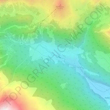
Name: Tschierv topographic map, elevation, terrain.
Average elevation: 6,637 ft
Minimum elevation: 5,299 ft
Maximum elevation: 9,439 ft
Other topographic maps
Click on a map to view its topography, its elevation and its terrain.
Minschuns
Switzerland > Grisons > Region Engiadina Bassa/Val Müstair > Val Müstair
Minschuns, Val Müstair, Region Engiadina Bassa/Val Müstair, Grisons, 7532, Switzerland
Average elevation: 7,454 ft