
Make a donation
Gear up for your next adventure:
As an Amazon Associate, this site earns from qualifying purchases at no extra cost to you.
Rosario topographic map
Click on the map to display elevation.
Make a donation
Gear up for your next adventure:
As an Amazon Associate, this site earns from qualifying purchases at no extra cost to you.
Rosario
The airport serves the Greater Rosario area and is the main hub for Sol Líneas Aéreas and is also served by Aerolíneas Argentinas, Copa and Gol Transportes Aéreos. There are domestic flights within Argentina from Rosario to Buenos Aires, Córdoba, Mar del Plata (via Buenos Aires), Mendoza (vía Córdoba), Santa Fe and Villa Gesell (via Buenos Aires) cities as well as international services to, Porto Alegre, Brazil, and Punta del Este, Uruguay (direct flight in summer and via Buenos Aires in fall, winter and spring). The airport is at an altitude of 25 metres (82 ft). Its longest runway measures 3,000 metres (9,843 ft).
Make a donation
Gear up for your next adventure:
As an Amazon Associate, this site earns from qualifying purchases at no extra cost to you.
About this map
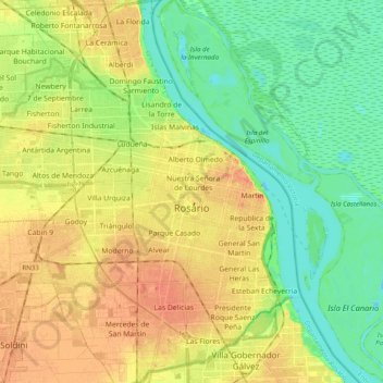
Name: Rosario topographic map, elevation, terrain.
Average elevation: 66 ft
Minimum elevation: -7 ft
Maximum elevation: 144 ft
Make a donation
Gear up for your next adventure:
As an Amazon Associate, this site earns from qualifying purchases at no extra cost to you.
Other topographic maps
Click on a map to view its topography, its elevation and its terrain.