Geolocate

Tarapoto topographic map

Click on the map to display elevation.

About this map

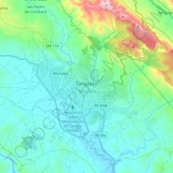
Name: Tarapoto topographic map, elevation, terrain.

Location: Tarapoto, Province of San Martín, San Martín, Peru (-6.56879 -76.40972 -6.41253 -76.33334)

Average elevation: 1,522 ft

Minimum elevation: 676 ft

Maximum elevation: 5,312 ft

Other topographic maps

Click on a map to view its topography, its elevation and its terrain.

Morro de Calzada

Peru > San Martín > Calzada > Calzada

Average elevation: 3,153 ft

Rey del Valle

Peru > San Martín > Alonso de Alvarado

Average elevation: 3,927 ft

Guantanamo

Peru > San Martín

Average elevation: 1,834 ft

San Andrés

Peru > San Martín > Jepelacio

Average elevation: 4,183 ft

Gear up for your next adventure:

🪵Folding Camp Saw - Compact saw for wood and campsite work
🔭Stargazing Telescopes - Perfect for camping in low-light pollution areas shown on maps
📱Heavy-Duty Phone Cases - Drop-proof and waterproof protection for outdoor navigation
🥄Camping Utensil Set - Lightweight utensils for outdoor meals
🔊Portable Camp Speaker - Music and alerts at camp

As an Amazon Associate, this site earns from qualifying purchases at no extra cost to you.