
Virac topographic map
Interactive map
Click on the map to display elevation.
About this map
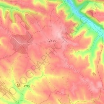
Name: Virac topographic map, elevation, terrain.
Location: Virac, Albi, Tarn, Occitania, Metropolitan France, 81640, France (44.02130 2.02497 44.06547 2.07452)
Average elevation: 968 ft
Minimum elevation: 659 ft
Maximum elevation: 1,109 ft
Other topographic maps
Click on a map to view its topography, its elevation and its terrain.
Lagarrigue
Lagarrigue, Castres, Tarn, Occitania, Metropolitan France, 81090, France
Average elevation: 699 ft
Saint-Sulpice-la-Pointe
Saint-Sulpice-la-Pointe, Castres, Tarn, Occitania, Metropolitan France, 81370, France
Average elevation: 453 ft
Pampelonne
Pampelonne, Albi, Tarn, Occitania, Metropolitan France, 81190, France
Average elevation: 1,306 ft
Lescure-d'Albigeois
Lescure-d'Albigeois, Albi, Tarn, Occitania, Metropolitan France, 81380, France
Average elevation: 656 ft
Las Planes
France > Occitania > Tarn > Senouillac > Las Planes
Las Planes, Senouillac, Albi, Tarn, Occitania, Metropolitan France, 81600, France
Average elevation: 630 ft
Le Vintrou
France > Occitania > Tarn > Le Vintrou
Le Vintrou, Castres, Tarn, Occitania, Metropolitan France, 81240, France
Average elevation: 2,001 ft
Cambon-lès-Lavaur
Cambon-lès-Lavaur, Castres, Tarn, Occitania, Metropolitan France, 81470, France
Average elevation: 755 ft