
Devils Canyon Dike Number 1 17-002 Dam topographic map
Interactive map
Click on the map to display elevation.
About this map
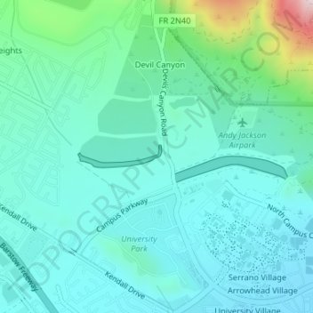
Name: Devils Canyon Dike Number 1 17-002 Dam topographic map, elevation, terrain.
Average elevation: 1,703 ft
Minimum elevation: 1,444 ft
Maximum elevation: 2,854 ft
Other topographic maps
Click on a map to view its topography, its elevation and its terrain.
City Creek
United States > California > San Bernardino County > San Bernardino
City Creek, San Bernardino, San Bernardino County, CAL Fire Southern Region, California, 92346, United States
Average elevation: 1,191 ft
Patton
United States > California > San Bernardino County > San Bernardino
Patton, San Bernardino, San Bernardino County, California, 92369, United States
Average elevation: 1,362 ft