
Make a donation
Gear up for your next adventure:
As an Amazon Associate, this site earns from qualifying purchases at no extra cost to you.
Ferdrupt topographic map
Click on the map to display elevation.
Make a donation
Gear up for your next adventure:
As an Amazon Associate, this site earns from qualifying purchases at no extra cost to you.
Ferdrupt
Le territoire de la commune est essentiellement montagneux et accidenté ; l'altitude minimale est de 444 m, la mairie est à 450 m tandis que l'altitude maximale y est atteinte sur la Tête de l'Homant (896 m) et du Grand Coteau à (903 m) bien que le véritable sommet à 905 m se situe sur la commune voisine de Saulxures-sur-Moselotte.
Make a donation
Gear up for your next adventure:
As an Amazon Associate, this site earns from qualifying purchases at no extra cost to you.
About this map
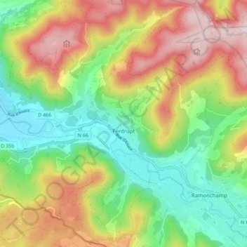
Name: Ferdrupt topographic map, elevation, terrain.
Average elevation: 2,070 ft
Minimum elevation: 1,401 ft
Maximum elevation: 2,972 ft
Make a donation
Gear up for your next adventure:
As an Amazon Associate, this site earns from qualifying purchases at no extra cost to you.
Other topographic maps
Click on a map to view its topography, its elevation and its terrain.
Le Haut du Tôt
France > Grand Est > Vosges > Sapois
Perché à 827 m d'altitude dans le massif des Vosges sur le versant nord de la vallée de la Moselotte, le Haut du Tôt est la plus haute paroisse du département des Vosges. Il ne constitue cependant pas une commune, ayant été partagé arbitrairement par une ligne nord-sud entre Vagney et Sapois.
Average elevation: 2,448 ft
Make a donation
Gear up for your next adventure:
As an Amazon Associate, this site earns from qualifying purchases at no extra cost to you.
Make a donation
Gear up for your next adventure:
As an Amazon Associate, this site earns from qualifying purchases at no extra cost to you.
Col de la Schlucht
France > Grand Est > Vosges > Le Valtin > La Schlucht
Situé à une altitude de 1 139 mètres, le col de la Schlucht fait communiquer les vallées lorraines de la Meurthe et de la Vologne avec la vallée alsacienne de la Fecht, un affluent de l'Ill. Les sources de la Meurthe et de la Fecht sont voisines du col de la Schlucht. La première coule sur les hauteurs…
Average elevation: 3,504 ft
Make a donation
Gear up for your next adventure:
As an Amazon Associate, this site earns from qualifying purchases at no extra cost to you.
Make a donation
Gear up for your next adventure:
As an Amazon Associate, this site earns from qualifying purchases at no extra cost to you.
Make a donation
Gear up for your next adventure:
As an Amazon Associate, this site earns from qualifying purchases at no extra cost to you.
Réserve naturelle de la Tourbière de Machais
France > Grand Est > Vosges > Le Régit
Average elevation: 3,271 ft
Make a donation
Gear up for your next adventure:
As an Amazon Associate, this site earns from qualifying purchases at no extra cost to you.
Make a donation
Gear up for your next adventure:
As an Amazon Associate, this site earns from qualifying purchases at no extra cost to you.
Le Derrière des Pres
France > Grand Est > Vosges > Saint-Maurice-sur-Moselle
Average elevation: 2,776 ft
Make a donation
Gear up for your next adventure:
As an Amazon Associate, this site earns from qualifying purchases at no extra cost to you.
Make a donation
Gear up for your next adventure:
As an Amazon Associate, this site earns from qualifying purchases at no extra cost to you.
Make a donation
Gear up for your next adventure:
As an Amazon Associate, this site earns from qualifying purchases at no extra cost to you.
Make a donation
Gear up for your next adventure:
As an Amazon Associate, this site earns from qualifying purchases at no extra cost to you.
Make a donation
Gear up for your next adventure:
As an Amazon Associate, this site earns from qualifying purchases at no extra cost to you.
Refuge du Sotré
France > Grand Est > Vosges > Xonrupt-Longemer > La Schlucht
Average elevation: 3,730 ft
les Mirabelliers
France > Grand Est > Vosges > Ban-de-Laveline > les Mirabelliers
Average elevation: 1,673 ft
Make a donation
Gear up for your next adventure:
As an Amazon Associate, this site earns from qualifying purchases at no extra cost to you.
Make a donation
Gear up for your next adventure:
As an Amazon Associate, this site earns from qualifying purchases at no extra cost to you.
Make a donation
Gear up for your next adventure:
As an Amazon Associate, this site earns from qualifying purchases at no extra cost to you.
Ferme de Vologne
France > Grand Est > Vosges > Xonrupt-Longemer > Ferme de Vologne
Average elevation: 2,644 ft
Make a donation
Gear up for your next adventure:
As an Amazon Associate, this site earns from qualifying purchases at no extra cost to you.
Make a donation
Gear up for your next adventure:
As an Amazon Associate, this site earns from qualifying purchases at no extra cost to you.
Make a donation
Gear up for your next adventure:
As an Amazon Associate, this site earns from qualifying purchases at no extra cost to you.
Make a donation
Gear up for your next adventure:
As an Amazon Associate, this site earns from qualifying purchases at no extra cost to you.
Make a donation
Gear up for your next adventure:
As an Amazon Associate, this site earns from qualifying purchases at no extra cost to you.
Make a donation
Gear up for your next adventure:
As an Amazon Associate, this site earns from qualifying purchases at no extra cost to you.
Make a donation
Gear up for your next adventure:
As an Amazon Associate, this site earns from qualifying purchases at no extra cost to you.
Make a donation
Gear up for your next adventure:
As an Amazon Associate, this site earns from qualifying purchases at no extra cost to you.
Make a donation
Gear up for your next adventure:
As an Amazon Associate, this site earns from qualifying purchases at no extra cost to you.
Make a donation
Gear up for your next adventure:
As an Amazon Associate, this site earns from qualifying purchases at no extra cost to you.