
Romão topographic map
Interactive map
Click on the map to display elevation.
About this map
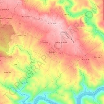
Name: Romão topographic map, elevation, terrain.
Location: Romão, Pedrógão Grande, Leiria, 3270-099, Portugal (39.87920 -8.19949 39.91920 -8.15949)
Average elevation: 1,017 ft
Minimum elevation: 558 ft
Maximum elevation: 1,302 ft
Other topographic maps
Click on a map to view its topography, its elevation and its terrain.
Graça
Portugal > Leiria > Pedrógão Grande
Graça, Pedrógão Grande, Leiria, Portugal
Average elevation: 1,096 ft
Troviscais Fundeiros
Portugal > Leiria > Pedrógão Grande
Troviscais Fundeiros, Pedrógão Grande, Leiria, 3270-066, Portugal
Average elevation: 1,201 ft
Pesos Cimeiros
Portugal > Leiria > Pedrógão Grande
Pesos Cimeiros, Pedrógão Grande, Leiria, 3270-066, Portugal
Average elevation: 1,266 ft
Ramalho
Portugal > Leiria > Pedrógão Grande
Ramalho, Vila Facaia, Pedrógão Grande, Leiria, 3270-225, Portugal
Average elevation: 1,207 ft
Atalaia Fundeira
Portugal > Leiria > Pedrógão Grande > Atalaia Fundeira
Atalaia Fundeira, Graça, Pedrógão Grande, Leiria, 6100-290, Portugal
Average elevation: 912 ft
Vila Facaia
Portugal > Leiria > Pedrógão Grande
Vila Facaia, Pedrógão Grande, Leiria, 3270-225, Portugal
Average elevation: 1,411 ft