
Tarmugli Island topographic map
Interactive map
Click on the map to display elevation.
About this map
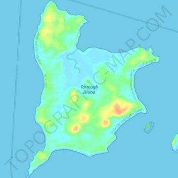
Name: Tarmugli Island topographic map, elevation, terrain.
Average elevation: 13 ft
Minimum elevation: -13 ft
Maximum elevation: 128 ft
Other topographic maps
Click on a map to view its topography, its elevation and its terrain.
South Andaman
India > Andaman and Nicobar Islands > Ferrargunj
South Andaman, Wimberleyganj, Ferrargunj, South Andaman District, Andaman and Nicobar Islands, India
Average elevation: 56 ft
North Sentinel Island
India > Andaman and Nicobar Islands > Ferrargunj
North Sentinel Island, Ferrargunj, South Andaman District, Andaman and Nicobar Islands, India
Average elevation: 66 ft