
Angern topographic map
Interactive map
Click on the map to display elevation.
About this map
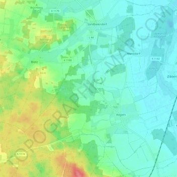
Name: Angern topographic map, elevation, terrain.
Location: Angern, Elbe-Heide, Börde, Sachsen-Anhalt, Deutschland (52.33361 11.66962 52.40288 11.79021)
Average elevation: 187 ft
Minimum elevation: 121 ft
Maximum elevation: 361 ft
Other topographic maps
Click on a map to view its topography, its elevation and its terrain.
Mahlwinkel
Deutschland > Sachsen-Anhalt > Börde > Angern
Mahlwinkel, Angern, Elbe-Heide, Börde, Sachsen-Anhalt, Deutschland
Average elevation: 138 ft