Geolocate

Bell Buckle topographic map

Click on the map to display elevation.

About this map
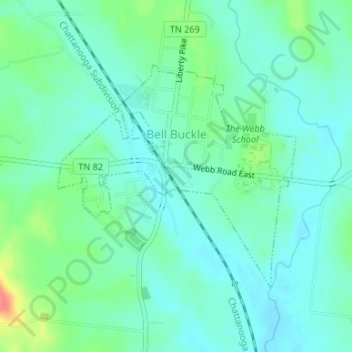
Name: Bell Buckle topographic map, elevation, terrain.

Location: Bell Buckle, Bedford County, Middle Tennessee, Tennessee, United States (35.57996 -86.36539 35.59707 -86.34289)

Average elevation: 866 ft

Minimum elevation: 814 ft

Maximum elevation: 1,020 ft

Bedford County trails, hiking, mountain biking, running and outdoor activities

Other topographic maps

Click on a map to view its topography, its elevation and its terrain.
Wheel

United States > Tennessee > Bedford County

Average elevation: 761 ft

Midway

United States > Tennessee > Bedford County

Average elevation: 925 ft

Haley

United States > Tennessee > Bedford County

Average elevation: 856 ft

Fairfield

United States > Tennessee > Bedford County

Average elevation: 886 ft

Cortner

United States > Tennessee > Bedford County

Average elevation: 869 ft

Cedar Grove

United States > Tennessee > Bedford County

Average elevation: 735 ft

Bottle Hollow

United States > Tennessee > Bedford County

Average elevation: 958 ft

Fall Creek

United States > Tennessee > Bedford County

Average elevation: 728 ft

Caldwell

United States > Tennessee > Bedford County

Average elevation: 863 ft

Gear up for your next adventure:

🥾Men's Hiking Boots - Durable, waterproof footwear for rugged terrain and steep inclines
🛡️Insect Repellent - Protection against bugs during outdoor activities
🪶Camping Sleeping Pad - Comfortable sleeping pad for backpacking
🔥Plasma Lighters - Windproof lighters that work in any weather condition
⌚Solar GPS Watches - Advanced multisport watches with built-in topographic maps

As an Amazon Associate, this site earns from qualifying purchases at no extra cost to you.