Geolocate

Oswaldtwistle topographic map

Click on the map to display elevation.

About this map

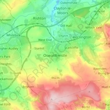
Name: Oswaldtwistle topographic map, elevation, terrain.

Location: Oswaldtwistle, Hyndburn, Lancashire, England, BB5 3HR, United Kingdom (53.69982 -2.43880 53.77982 -2.35880)

Average elevation: 666 ft

Minimum elevation: 269 ft

Maximum elevation: 1,237 ft

Other topographic maps

Click on a map to view its topography, its elevation and its terrain.

Altham

United Kingdom > England > Lancashire > Hyndburn > Altham

Average elevation: 400 ft

Gear up for your next adventure:

🧷Carabiner Set - Durable clips for gear attachment
🧭Pro Hiking Compasses - High-accuracy liquid-filled compasses for topographic orientation
🥄Camping Utensil Set - Lightweight utensils for outdoor meals
🛏️Cold Weather Sleeping Bag - Warm sleeping bag for cold conditions
🧤Hiking Gloves - Protective gloves for rugged trails

As an Amazon Associate, this site earns from qualifying purchases at no extra cost to you.