
Make a donation
Gear up for your next adventure:
As an Amazon Associate, this site earns from qualifying purchases at no extra cost to you.
Portersville topographic map
Click on the map to display elevation.
Make a donation
Gear up for your next adventure:
As an Amazon Associate, this site earns from qualifying purchases at no extra cost to you.
About this map
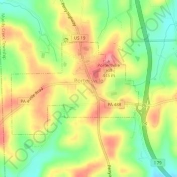
Name: Portersville topographic map, elevation, terrain.
Location: Portersville, Butler County, Pennsylvania, United States (40.91726 -80.15989 40.93134 -80.13413)
Average elevation: 1,309 ft
Minimum elevation: 1,158 ft
Maximum elevation: 1,450 ft
Butler County trails, hiking, mountain biking, running and outdoor activities
Make a donation
Gear up for your next adventure:
As an Amazon Associate, this site earns from qualifying purchases at no extra cost to you.
Other topographic maps
Click on a map to view its topography, its elevation and its terrain.
Greece City
United States > Pennsylvania > Butler County > Concord Township
Average elevation: 1,227 ft
Glade Mills
United States > Pennsylvania > Butler County > Middlesex Township
Average elevation: 1,178 ft
Bonnie Brook
United States > Pennsylvania > Butler County > Summit Township
Average elevation: 1,204 ft
Hilliards
United States > Pennsylvania > Butler County > Washington Township
Average elevation: 1,404 ft
Make a donation
Gear up for your next adventure:
As an Amazon Associate, this site earns from qualifying purchases at no extra cost to you.
Bonnie Brook
United States > Pennsylvania > Butler County > Summit Township
Average elevation: 1,204 ft
Butler Farm Show Lake
United States > Pennsylvania > Butler County > Meridian
Average elevation: 1,286 ft
Make a donation
Gear up for your next adventure:
As an Amazon Associate, this site earns from qualifying purchases at no extra cost to you.
Cunningham
United States > Pennsylvania > Butler County > Clinton Township
Average elevation: 1,106 ft