Geolocate

Friendship topographic map

Click on the map to display elevation.

About this map
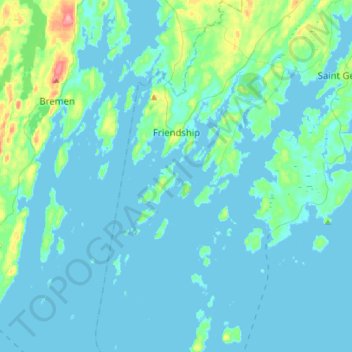
Name: Friendship topographic map, elevation, terrain.

Location: Friendship, Knox County, Maine, 04547, United States (43.85797 -69.39818 44.05899 -69.27669)

Average elevation: 33 ft

Minimum elevation: -7 ft

Maximum elevation: 295 ft

Knox County trails, hiking, mountain biking, running and outdoor activities

Other topographic maps

Click on a map to view its topography, its elevation and its terrain.
Port Clyde

United States > Maine > Knox County > Saint George

Average elevation: 16 ft

Spruce Head

United States > Maine > Knox County

Average elevation: 23 ft

Mark Island

United States > Maine > Knox County > North Haven

Average elevation: 0 ft

Indian Island

United States > Maine > Knox County > Rockport

Average elevation: 10 ft

Port Clyde

United States > Maine > Knox County

Average elevation: 16 ft

Folly Pond

United States > Maine > Knox County > Vinalhaven

Average elevation: 52 ft

Gear up for your next adventure:

👖Convertible Hiking Pants - Versatile zip-off pants for changing altitudes and temperatures
🏕️Tent Footprint - Protect your tent base from wear
🥇GPS Hiking Watch - Multi‑sport GPS watch with navigation and trail tracking
🛠️Backpacking Tool Kit - Essential toolkit for outdoor repairs
🧣Hiking Neck Gaiter - Multi‑use neck protection for outdoor weather

As an Amazon Associate, this site earns from qualifying purchases at no extra cost to you.