
Qanawat topographic map
Interactive map
Click on the map to display elevation.
About this map
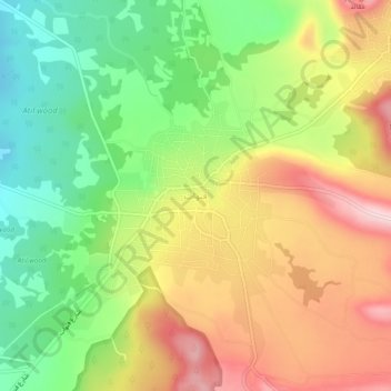
Name: Qanawat topographic map, elevation, terrain.
Average elevation: 3,967 ft
Minimum elevation: 3,537 ft
Maximum elevation: 4,452 ft
Other topographic maps
Click on a map to view its topography, its elevation and its terrain.
Al Kafr
Syria > As-Suwayda Governorate
Al Kafr, As-Suwayda Subdistrict, As-Suwayda District, As-Suwayda Governorate, Syria
Average elevation: 4,439 ft
Shahba
Syria > As-Suwayda Governorate > Shahba
Shahba, Shahba Subdistrict, Shahba District, As-Suwayda Governorate, Syria
Average elevation: 3,533 ft