Geolocate

Woolwine topographic map

Click on the map to display elevation.

About this map
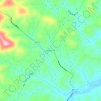
Name: Woolwine topographic map, elevation, terrain.

Location: Woolwine, Patrick County, Virginia, 24185, United States (36.76986 -80.29728 36.80986 -80.25728)

Average elevation: 1,490 ft

Minimum elevation: 1,234 ft

Maximum elevation: 2,123 ft

Patrick County trails, hiking, mountain biking, running and outdoor activities

Other topographic maps

Click on a map to view its topography, its elevation and its terrain.
Stuart

United States > Virginia > Patrick County

Average elevation: 1,348 ft

Fairy Stone Lake

United States > Virginia > Patrick County

Average elevation: 1,109 ft

Stuart

United States > Virginia > Patrick County

Average elevation: 1,348 ft

Patrick Springs

United States > Virginia > Patrick County

Average elevation: 1,276 ft

Stuart

United States > Virginia > Patrick County

Average elevation: 1,365 ft

Gear up for your next adventure:

🪶Survival Guide Book - Expert advice for emergency preparedness
🖼️Topo Map Wall Art - Decorative topographic prints of famous peaks and regions
🥩Freeze-Dried Meals - Nutritious and lightweight food for remote expeditions
☕Camping Coffee Makers - Enjoy premium coffee at the summit or campsite
🛶Inflatable Kayak - Portable kayak for rivers, lakes, and expeditions

As an Amazon Associate, this site earns from qualifying purchases at no extra cost to you.