Geolocate

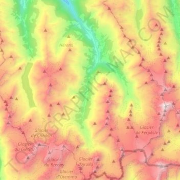
Evolène topographic map

Click on the map to display elevation.

Evolène

At precisely 8.27 pm, the first two avalanches were set off on the slopes above Villa, at an altitude around 2,600 m (8,500 ft). They were a combination of fresh powder snow and established spring snow and demolished all trees and chalets in their path, as well as the people unlucky enough to be in the chalets at the time. The two avalanches continued to run along the extremities of Villa and eventually formed as one massive fusion of snow and debris reaching up to 15 m (49 ft) high that came to rest 1,000 m (3,300 ft) down the slope, after taking 12 lives and cutting off the main road between Evolène and des Haudères.

Wikipedia (CC-BY-SA 3.0)

About this map

Name: Evolène topographic map, elevation, terrain.

Location: Evolène, Hérens, Wallis, 1983, Switzerland (45.95490 7.42553 46.14706 7.61195)

Average elevation: 8,848 ft

Minimum elevation: 3,704 ft

Maximum elevation: 14,272 ft

Other topographic maps

Click on a map to view its topography, its elevation and its terrain.

Arolla

Switzerland > Wallis > Hérens

Average elevation: 7,864 ft

Villa (Evolène)

Switzerland > Wallis > Hérens

Average elevation: 6,381 ft

Les Haudères

Switzerland > Wallis > Hérens

Average elevation: 6,158 ft

Les Collons

Switzerland > Wallis > Hérens > Vex

Average elevation: 5,203 ft

Les Bochonès

Switzerland > Wallis > Hérens > Ayent > Anzère

Average elevation: 5,210 ft

La Sage

Switzerland > Wallis > Hérens

Average elevation: 6,198 ft

Nax

Switzerland > Wallis > Hérens > Mont-Noble

Average elevation: 3,248 ft

Taillau

Switzerland > Wallis > Hérens > La Sage

Average elevation: 6,184 ft

Bonnefille

Switzerland > Wallis > Hérens > Ayent > Anzère

Average elevation: 4,619 ft

Luc (Ayent)

Switzerland > Wallis > Hérens > Ayent

Average elevation: 3,468 ft

La Gouille

Switzerland > Wallis > Hérens > Evolène

Average elevation: 7,612 ft

Baule

Switzerland > Wallis > Hérens > Saint-Martin (VS) > St-Martin VS

Average elevation: 4,721 ft

Molignon

Switzerland > Wallis > Hérens > Les Haudères

Average elevation: 5,961 ft

Schnidehorn

Switzerland > Wallis > Hérens > Ayent

Average elevation: 8,419 ft

Trogne (St-Martin)

Switzerland > Wallis > Hérens > Saint-Martin (VS)

Average elevation: 5,184 ft

Lac de Tseuzier

Switzerland > Wallis > Hérens > Ayent

Average elevation: 6,138 ft

La Grande Dixence

Switzerland > Wallis > Hérens > Hérémence

Average elevation: 7,979 ft

Pralovin

Switzerland > Wallis > Hérens > Les Haudères

Average elevation: 6,424 ft

Les Maresses

Switzerland > Wallis > Hérens > Mont-Noble > Vernamiège

Average elevation: 5,436 ft

Les Bochonès

Switzerland > Wallis > Hérens > Ayent > Anzère

Average elevation: 5,210 ft

Mase

Switzerland > Wallis > Hérens > Mont-Noble

The village is located in the Hérens district on the right bank of the Borgne and the left bank of the Rhone in the Val d'Hérens at an elevation of 1,345 m (4,413 ft). It consists of the village of Mase.

Average elevation: 4,173 ft

Gear up for your next adventure:

🌎3D Topographic Globes - Raised relief globes for a tactile understanding of geography
🥾Men's Hiking Boots - Durable, waterproof footwear for rugged terrain and steep inclines
🎒Day Hiking Backpack - Lightweight backpack perfect for day trips and outdoor adventures
👟Trail Running Shoes - Lightweight shoes for trail runners
🧭Compass with Lanyard - Easy‑carry compass for navigation

As an Amazon Associate, this site earns from qualifying purchases at no extra cost to you.